
by Bethanie Harriman – EMTV News, Lae
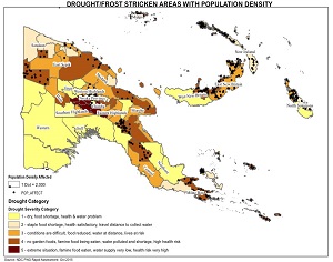
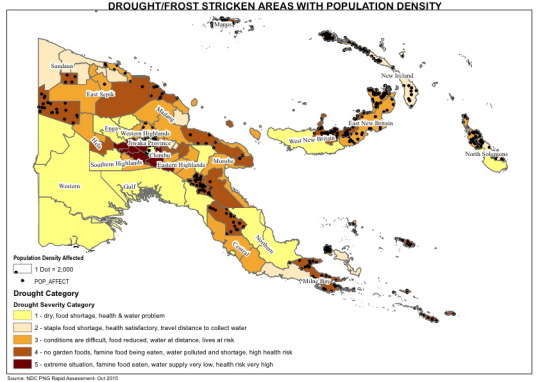
The National Agricultural Research Institute has released a map showing areas critically affected by the drought.
Provinces facing severe food and water shortages show on the five-day-old map.
National Research Institutes Maps Expert, Moses Robby, said the Map also shows places like East New Britain, Morobe and East Sepik moving toward the extreme stages of drought.
“In the next several months, we will see changes in the map,” said Robby.
Places in Chimbu, Eastern and Western Highlands face extreme stages of drought where there are shortages of food, depleting water supply and high risk of water Bourne sickness
The map isn’t meant to cause panic, but it was displayed in public at the Morobe Show last week to draw attention to the plight of people in Jiwaka and Southern Highlands Provinces who face extreme situations.
In Parliament this week, Finance Minister, James Marape said the government has instructed members of parliament to put aside two million kina of District funds to supply relief assistance for affected areas.
The National Agriculture Research Institute has promoted early maturing crops for drought recovery in communities.
Its will cost K2 million to distribute sweet potatoes cuttings to places between December and February when the brief rains come.
https://youtube.com/watch?v=Jo8l8VkYZGI%3Ffeature%3Doembed%26wmode%3Dopaque%26showinfo%3D0%26showsearch%3D0%26rel%3D0