
A Storm Force winds and high seas warnings have been issued by PNG National Weather Service with close consultation with the Australian Bureau of Meteorology’s Queensland Tropical Cyclone Warning Centre at 6:30 am on Friday 23rd March 2018.
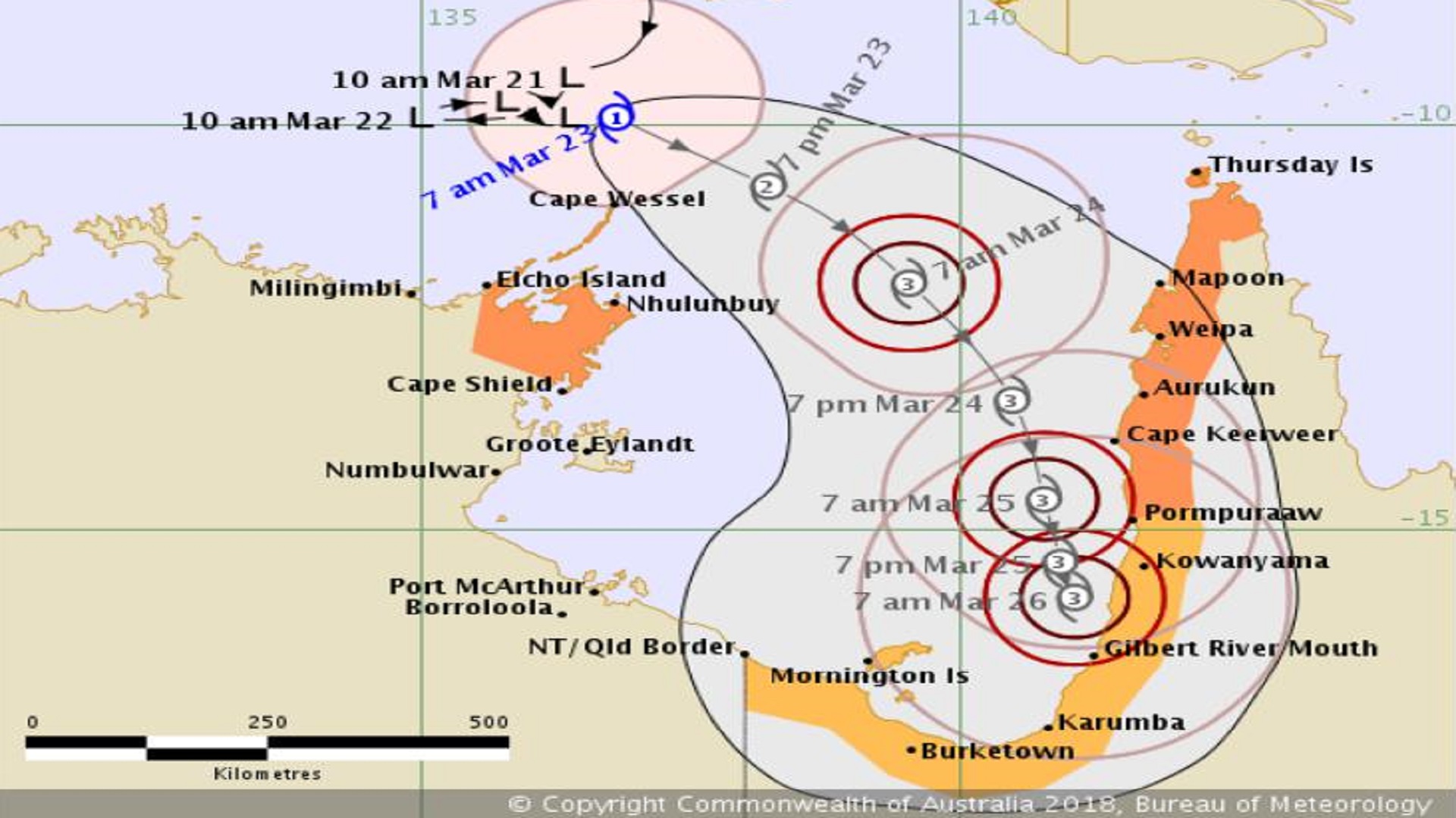
Tropical Cyclone Nora, located off the Northern Territory northeast coast, is slowly moving east and intensifying.
Tropical Cyclone Nora is currently moving slowly eastwards but will begin a more south easterly path during today and Saturday into the Gulf of Carpentaria. The system is expected to reach Category 2 today and reach Category 3 early Saturday. By Sunday, the Tropical Cyclone will most likely be located over the southern Gulf of Carpentaria. A coastal crossing anywhere along the Western Cape York Peninsula south of Weipa during Saturday or Sunday is possible.
Hazards
Gales warnings have been issued for the areas between northern PNG/ Indonesian Border, West Sepik, East Sepik and Madang and the Bismarck Sea by Friday and Storm wind warning has been issued for PNG/ Indonesian border and Kiwai Islands, including Lake Murray, Suki, Fly Gogodala villages and the South Fly. Heavy rainfall is forecast for Western, Gulf and Highlands region over the coming days, which could potentially lead to flash flooding in parts of the areas.
As tropical cyclone Nora continues to intensify rapidly, abnormally high tides and high seas warning has been issued for the areas between PNG/Indonesian Border and Daru Island. Large waves are expected to reach the coastal areas.
NDC and PNG National Weather Service advise communities under Watch:
– People between PNG/ Indonesian border and Kiwai Islands, including Lake Murray, Suki, Fly Gogodala villages and the South Fly must keep your home, yard and family in a safe area away from the storm force winds.
Areas Affected
Between southern PNG/ Indonesian border and Kiwai Islands, including Lake Murray, Suki and Fly Gogodala villages and South Fly.
Outlook for the Week (22-29 March 2018)
Strong northwesterly winds will prevail across the country throughout the week (Figure 11 & 13). Strong wind warning is current from PNG Indonesian border to Wewak and to Madang to Finchafen, Vitiaz Strait, Dampier Strait to Siassi Islands to Long Island and New Guinea Islands. Storm winds and high seas warnings have been issued for Western Province and Torres Strait Islands.
Cloudy periods with afternoon and evening rain or thundery showers are expected over most of the country whilst moderate to heavy rainfall with possible thunderstorms is expected to occur in the Highlands and Papuan regions
-PNG National Weather Service-